
6-minute read
In this article:
- Get an overview of the comprehensive inspection services that Clearsight offers.
- Learn how LiDAR and satellite technology works and can be applied.
- Discover how our LiDAR and satellite applications have the potential to save electric cooperatives on costs.
Constellation Clearsight has become a trusted inspection ally for utilities and cooperatives seeking to ensure the safety and reliability of their infrastructure. One area where our clients could greatly benefit from supplementary services is vegetation management.
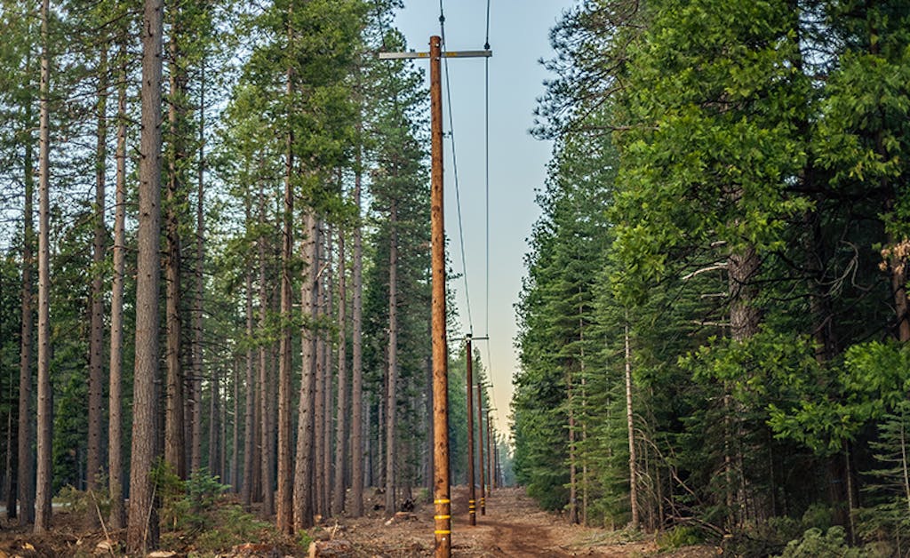
As any utility and electric cooperative knows, vegetation growth poses a potential threat to electric assets, including poles and power lines. Without effective vegetation management, trees can lead to outages, damage, and safety concerns.
For customers planning summer and fall wood pole inspections, we strongly advise consulting our experts to explore the benefits of integrating LiDAR or satellite-based vegetation management services. By using these advanced technologies, utilities and electric cooperatives can identify potential vegetation issues before they become serious problems.
About Our Comprehensive Inspection Services
Clearsight’s comprehensive inspection services are fully customizable to meet the needs of your utility or cooperative. Using advanced technology and expert analysis, we quickly and efficiently identify potential issues with overhead power lines, including signs of wear and tear, damage, and other safety concerns.
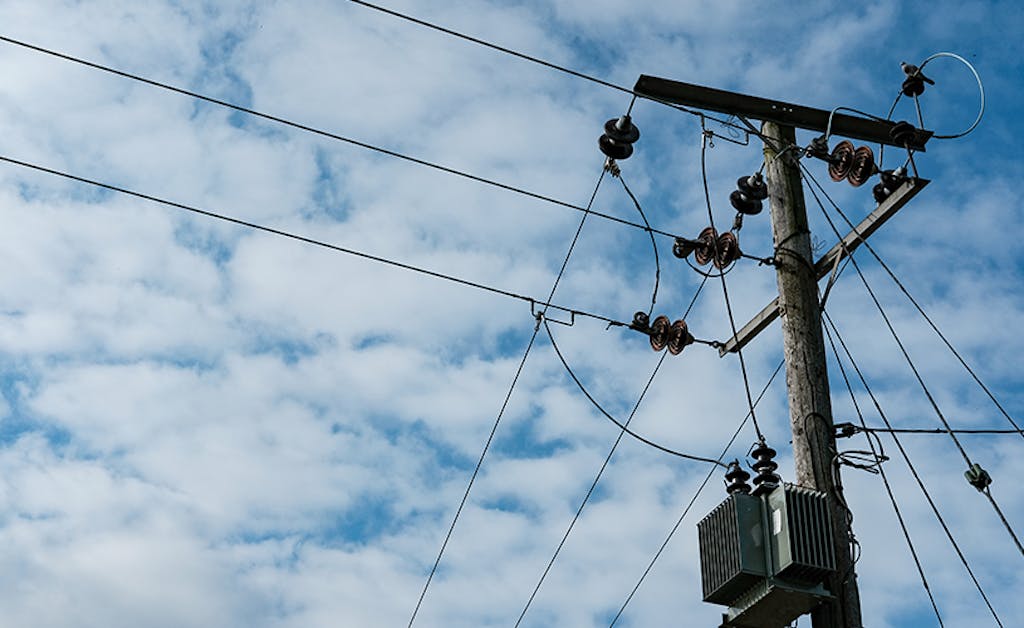
Our inspections utilize state-of-the-art drones, allowing our seasoned operators to access hard-to-reach areas and provide detailed visual inspections from every angle. By utilizing innovative technology, such as drones, machine learning (ML), and artificial intelligence (AI), we provide our customers with the most comprehensive and accurate picture of their infrastructure’s health and safety.
What is LiDAR and Satellite Technology?
LiDAR, or Light Detection and Ranging, uses laser light to create a detailed 3D map of the environment. With LIDAR, utilities and electric cooperatives can identify potential issues with vegetation growth near utility poles, even in areas that are difficult to access. For example, LIDAR can detect overhanging branches or other vegetation that may be too close to the poles, potentially causing damage or outages during storms or high winds.
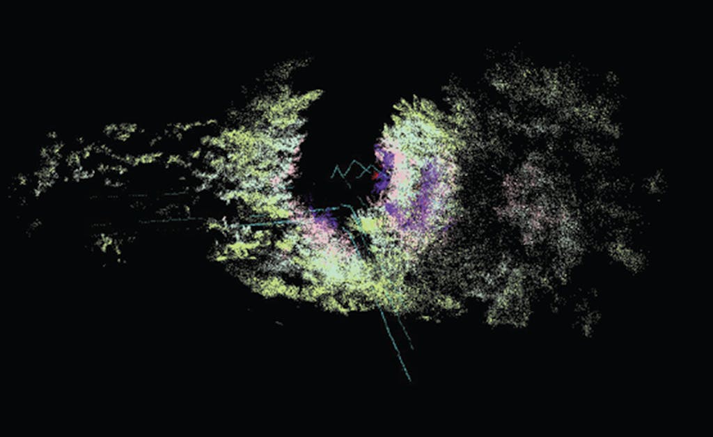
LiDAR goes beyond the human eye by giving you the entire corridor the electric assets run and allows the viewer to pinpoint hazards both at ground, at wire, and at bird’s-eye view – all in the same 3D map.
Similarly, satellite vegetation management services can provide utilities and electric cooperatives with a bird’s-eye view of their infrastructure and surrounding areas. A comprehensive satellite assessment can identify tree species, relative health, degrees of encroachment towards electric lines and fall-in risk from off right-of-way trees.
Related: Here’s How Our Methods Can Help Solve Vegetation Management Problems
By analyzing satellite imagery, you can identify potential vegetation issues across wide areas, helping prioritize and plan maintenance efforts more effectively. This can help to reduce the risk of outages and other issues caused by vegetation growth.
Cost Optimization: Increasing Reliability and Efficiency
As previously mentioned, we recommend customers consider adding vegetation management inspections to summer and fall planned work. Integrating vegetation management inspections with aerial line and wood pole inspections offers several significant benefits:
- Maximizes resource use and streamlines maintenance activities
- Minimizes the need for multiple site visits, reducing labor costs and improving overall efficiency
- Provides a better understanding of total infrastructure health, enabling the early detection of potential issues
- Helps minimize the likelihood of outages, damage to wooden poles, and safety hazards caused by falling branches or tree contact with power lines
Adding LiDAR and/or satellite further increases these benefits. LiDAR and satellite technologies quickly and efficiently survey large areas with minimal human intervention – translating into potentially significant cost savings.
The cost of using LiDAR and satellite technologies for vegetation management inspections has decreased dramatically over the past decade, making these solutions more accessible and cost-effective. The combination of increased efficiency and reduced costs has made LiDAR and satellite technologies an attractive option for vegetation management inspections.
Where Clearsight Can Help
Incorporating these technologies into vegetation management efforts requires expertise and experience. That’s where Constellation Clearsight comes in. Our team of experts will work with you to develop a customized inspection (including a vegetation management plan) that takes advantage of the latest technologies and best practices. We help identify potential issues, prioritize maintenance efforts, and take proactive steps to ensure the safety and reliability of your infrastructure.
Bottom Line
We believe that LIDAR and satellite vegetation management services are valuable additions to any utility pole inspection effort. By using these technologies, you can identify potential vegetation issues before they become serious problems, helping to reduce the risk of outages, damage, and safety concerns.
If you are looking to enhance your vegetation management efforts, we encourage you to consider contacting us. Our team of experts can help you to develop a customized plan that meets your unique needs and provides the best possible protection for your infrastructure.
Related Content

Utility Pole Inspections: A Day in the Life of a Clearsight Drone Operator
Drones improve safety and data capture for utility pole inspections. Here’s what that looks like…

Vegetation Management: The Benefits of LiDAR Technology
Discover the benefits of LiDAR inspections and the factors to consider before implementing them.
